A tornado watch has been issued for McHenry County and northern Illinois Thursday afternoon.
The National Weather Service issued the watch at 1:55 p.m. Thursday and it is set to expire at 9 p.m. Thursday.
The tornado watch comes as a round of storms clears the area but a second round is anticipated to come through later in the day.
That round carries a threat for strong tornadoes.
Thursday’s severe weather comes as the area cleans up from Wednesday’s weather.
The National Weather Service received a report of 60 mph winds near Union and a tree down and a branch down in the road near the intersection of Indigo Drive and Russet Road in Algonquin.
But the weather bureau was still gathering information about Wednesday’s storms as it figures out what’s happening Thursday, Eric Lenning, a meteorologist at the National Weather Service said.
Whether Wednesday’s storms produced a derecho has not yet been finalized. A derecho needs to be a solid line of storms, and the path length has to be long. Lenning said it had to be at least 250 miles of destruction along the path.
While damage Wednesday was reported form Eastern Nebraska to Michigan, Lenning said he wasn’t sure yet if it was all the same system.
Thursday contains two waves of weather, the first wave of which was going from McHenry County to Galesburg, Lennning said. It was a bowing line but mainly gusty winds and heavy rains.
But the second round of storms is the larger concern, Lenning said.
While the first wave of storms could use up some of the fuel, it is possible the atmosphere could destabilize behind the storms. How unstable the atmosphere could be is still uncertain, Lenning said.
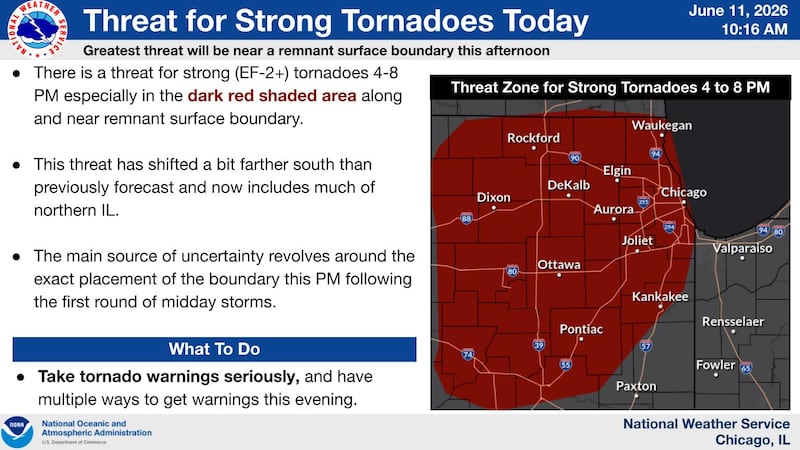
The weather service said there is a strong threat for tornadoes from 4 to 8 p.m. for the Chicago area and much of northern Illinois.
Flash floods are another potential risk. The weather service said heavy downpours may cause “widespread ponding” on roads and parking lots, and there could be isolated flooding of roads and urban areas. The storms could bring localized rainfall rates of 1 to 3 inches per hour, and the risk runs through Thursday evening.
People should use caution when driving through heavy rain and never drive or walk across flooded roads.
National Weather Service Meteorologist Gino Izzi said people who live near rivers and flood-prone areas should keep an eye on the weather and be prepared to move to higher ground if needed.
As of 11:40 a.m. Thursday, 888 ComEd customers in McHenry County were without power, according to the utility company’s website.
The forecast prompted Woodstock officials to reschedule a showing of the Wizard of Oz scheduled for Thursday in Woodstock Square to Aug. 6. Wednesday’s weather also prompted the cancellation of a Woodstock City Band concert for Woodstock Square that evening.
Woodstock Water Works was closed for the day Thursday because of the weather.