Since May 18, 2000, Kankakee County has experienced 43 instances of tornadoes, according to data from the National Weather Service.
While there were no reported tornadoes in 2025, there were five reported in 2024 and, of course, the EF-3 classified tornado on March 10. Those in the public may be beginning to wonder if there has been a shift in the path of these dangerous storms.
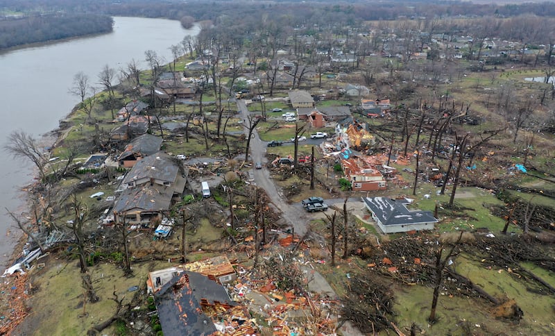
Based on the massive destruction from the March 10 tornadoes, which ripped through significant portions of Kankakee and Aroma Township – as well as subsequent tornado warnings – residents might be thinking the Kankakee River Valley is not only an area where corn, soybeans and wheat sprout, but also an area at a heightened risk for growth of tornado occurrence.
There may be a logical explanation for this growth in tornado activity. Simply put, radar technology and education have made the reporting of tornadoes a more exact science.
Ricky Castro, a meteorologist with the National Weather Service in Romeoville, noted this week that greater technology and trained weather spotters mean storms that may have previously been classified as a bad storm are now being pinned as tornadoes.
“It’s quite likely some tornados would have been considered wind damage,” he said. He said without the radar data, so much information would not have been known.
The data actually can reveal the rotation of each tornado.
“We’ve learned so much more. We have so many more reliable spotters. There is so much training, and the radar technology has so improved,” he said.
The technology can spot these low-level rotations.
And this technology is not only useful in properly classifying what type of storms have struck a community but also helps warn residents and public safety leaders about approaching dangers.
With the March 10 storm, weather technology was able to caution the community as early as 48 hours prior to the storm’s arrival in south Kankakee just after 6 p.m. that day.
Technology was also able to confirm the March 10 storms produced 10 separate tornadoes that hit eastern Kankakee County beginning at Pontiac to Dunns Bridge, Indiana.
:quality(70)/cloudfront-us-east-1.images.arcpublishing.com/shawmedia/CT65MZGJSNDJPELTLIKYA4IUTY.png)
These twisters ranged in intensity from EF-0 to EF-3. It was an EF-3 that came through south Kankakee and Aroma Township, causing the massive damage in these areas.
Six of the confirmed tornadoes were classified as EF-U. An EF-U tornado means an unknown tornado touched down but caused no surveyable damage to structures or trees, making its intensity impossible to determine.
:quality(70)/cloudfront-us-east-1.images.arcpublishing.com/shawmedia/RZIWUBBVR5EBHH7INXEX7JA3XE.png)
On the upswing?
Is eastern Illinois – the home of Kankakee, Iroquois, Will and Grundy counties, among many others – the new landing spot of tornadoes?
Illinois had more than 140 tornadoes last year, putting it neck and neck with Texas for the most of any U.S. state. And numbers across the country have been rising over the past 50 years.
The answer to that question, however, is simply no.
Tony Lyza, a meteorologist and tornado expert with the National Severe Storms Laboratory, a research lab with the National Oceanic and Atmospheric Administration, explained the Kankakee County region and its neighbors lag behind the so-called Tornado Alley of Texas, Oklahoma and Kansas.
“The short answer is no,” he explained this week in a telephone interview. “We are not seeing a dramatic shift.”
He said the eastern Illinois region is unfortunately very familiar with tornadoes, but not to the extent of other areas.
“Over time there may be some subtle shift into this region ... but in reality,” that is not the case, he said.
One thing Kankakee can lay claim to is the largest hail ever to be recorded in the history of the United States for any area east of the Mississippi River, he said.
The hailstones of some 6-inches in diameter will go down in history.
Lyza said it couldn’t be stated with total certainty that a hailstone of that size has never fallen east of the Mississippi. But one has never been captured, as was common with the Kankakee storm.
“Hail is very difficult to record because it can fall where no one saw the hailstone. Unfortunately, these hailstones fell in the city of Kankakee. They were hard to miss,” he said.
He also noted the duration of the March 10 tornado was highly unusual.
He noted the tornado touched down at 6:21 p.m. in Kankakee and was on the ground until 7:39 p.m., a time span of a whopping 78 minutes.
“That is unusual,” he said.
Tornadoes, a recent Chicago Sun-Times report noted, have ripped through Illinois for more than a century. The deadliest tornado in U.S. history passed through Southern Illinois, Missouri and Indiana in 1925, killing almost 700 people.
The most recent EF-3 powered tornado to land in Kankakee County was late evening June 5, 2010, also in Aroma Park.
Interestingly, an April 20, 2004, tornado, this one rated an F-0, which was prior to the upgraded EF rating classification, also traveled through south Kankakee. Its path through Kankakee was very similar to the March 10 tornado and caused significant damage also along South Schuyler Avenue.
The Will County region, in particular Plainfield, fell victim to a significant tornado in Plainfield in 1990, killing 29, injuring hundreds, and causing $165 million in damage.
The Aroma Township and Kankakee tornado, Lyza said, is not unprecedented for this region.
He added it will take decades to determine if there is an upswing in tornados.
‘Very sobering’
According to some definitions, Illinois has actually been considered part of Tornado Alley for some time. Initially, the nickname applied to southwestern states, including Kansas, Oklahoma, and Texas that were ravaged by twisters in the 1900s.
But weather patterns over the past half century have pointed to a rising number of tornadoes east of the Mississippi River.
Castro said severe weather can be trending higher, but the technology also aids in these storm classifications.
“We now have the information to say ‘Yes, that was a tornado.’” he said.
He added it cannot be said with total certainty there will be increasing numbers of these events in the coming years, but at the same time “it can’t be ruled out.”
And, he noted, tornadoes often follow a river valley path and Kankakee County is home to the Kankakee River valley.
He spent two days in the Aroma Township area viewing damage and evidence.
“It’s the worst damage I’ve ever seen,” he said, noting he’s viewed many areas where tornadoes have struck. “In terms of my own experience, this was the worst. It’s very sobering.”
:quality(70)/author-service-images-prod-us-east-1.publishing.aws.arc.pub/shawmedia/dfb924db-1795-46ea-afb4-ba3c95e55c46.jpg)