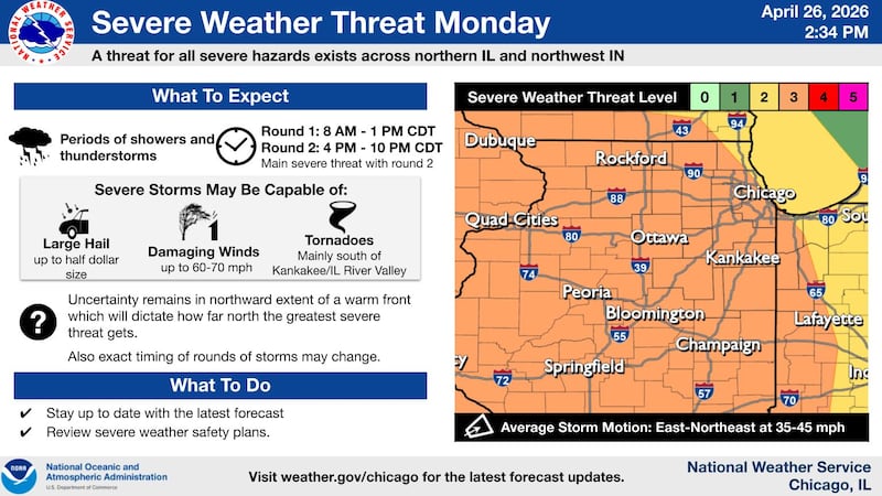
A volatile spring weather setup is expected to bring multiple rounds of storms and the potential for damaging winds and hail across northern Illinois on Monday, according to the National Weather Service.
Forecasters say the day will likely begin with a round of showers and thunderstorms moving into the region during the morning, especially along and south of Interstate 80. While this first batch is expected to weaken as it pushes east, a few stronger pockets could still produce isolated gusty winds.
The greater concern arrives later in the day.
A second, more organized round of storms is expected to develop between about 4 and 11 p.m., as a strengthening storm system comes into northern Illinois. This evening activity will have a better chance to become severe, with damaging wind gusts and large hail as the primary threats. Wind gusts could exceed 60 mph in stronger storms.
While the overall tornado risk appears lower for northern Illinois, it is not zero. The highest tornado potential is expected to remain farther south, generally south of the Kankakee and Illinois River valleys, but forecasters caution that any northward shift in a warm front could bring a more significant threat farther north.
In addition to thunderstorms, meteorologists are also monitoring the potential for a brief period of strong, non-thunderstorm winds midday, particularly north of I-80. These winds could develop between noon and 3 p.m.
Uncertainty remains regarding exactly how far north the most intense weather will reach, as cloud cover and earlier storms could limit instability. Still, the overall setup supports an active weather day across much of the region, including communities such as DeKalb, Ottawa, and Kankakee.
Conditions are expected to turn cooler and drier by midweek, with highs dropping into the 60s and the potential for frost by next weekend.
Residents are encouraged to stay weather-aware throughout the day and have multiple ways to receive warnings, especially during the evening hours when severe storms are most likely.
:quality(70)/author-service-images-prod-us-east-1.publishing.aws.arc.pub/shawmedia/59fc2deb-4690-4608-b846-d6af698839c4.png)