Northern Illinois residents could experience nearly every type of weather in the next 24 hours as a powerful storm system sweeps through the Midwest.
Forecasters with the National Weather Service say the system will bring powerful winds, thunderstorms, and a transition to snow from Sunday into early Monday across much of the region.
Parts of western Illinois already are under a Blizzard Warning issued by the National Weather Service Quad Cities beginning Sunday evening. The warning includes areas near the Mississippi River, including Whiteside and Carroll counties, along with Bureau County, where forecasters say strong winds and falling snow could combine to create near-whiteout conditions overnight into Monday morning.
Strong winds expected today
Before the snow arrives, strong southerly winds are expected to develop by mid-morning Sunday and strengthen through the afternoon.
:quality(70)/cloudfront-us-east-1.images.arcpublishing.com/shawmedia/6GI5K7VJH5GCHOTNW3VAJYI36Y.png)
Wind gusts of 45 to 50 mph are expected across much of northern Illinois. Even stronger gusts — 55 to 65 mph — are possible farther east along the Interstate 57 corridor.
The winds are expected to increase quickly between 9 and 11 a.m. and continue through the afternoon and evening, potentially making travel difficult and bringing down tree limbs.
Storms could bring damaging winds
Showers and thunderstorms are expected to develop in waves throughout the day on Sunday.
The first round could move through late Sunday morning, bringing lightning, heavy rain and possibly small hail.
A second round later in the day could be more concerning. Forecasters say a narrow band of storms may sweep across northern Illinois between 4 and 9 p.m.
:quality(70)/cloudfront-us-east-1.images.arcpublishing.com/shawmedia/65SFFXNIRZAPJIGN23GXUZSLTY.png)
,
Even though the storms may appear relatively weak on radar, they could tap into very strong winds already present in the atmosphere, producing damaging wind gusts of 60 to 75 mph in isolated areas.
While the tornado threat appears relatively low, meteorologists say brief,, weak tornadoes cannot be completely ruled out.
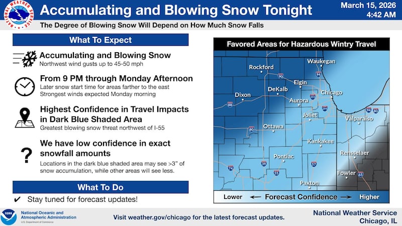
Snow and blowing snow overnight
As the storm system pulls away Sunday night, colder air will rush into the region, and rain could transition to snow in parts of northern Illinois.
:quality(70)/cloudfront-us-east-1.images.arcpublishing.com/shawmedia/ACYNVR4NXNEXNJ23O7JMQPMUMY.png)
on
Strong northwest winds — gusting 45 to 55 mph — could combine with falling snow to create blowing snow and hazardous travel conditions overnight into Monday morning, particularly in parts of western and northern Illinois.
Forecast confidence in snowfall totals remains low, but some areas could see several inches of accumulation, which could easily blow around in the strong winds.
Bitter cold follows
Behind the storm system, temperatures will drop sharply on Monday.
High temperatures may only reach the low 20s, while strong northwest winds could make it feel closer to the single digits.
Wind chills could fall to 5 to 10 below zero Monday night into Tuesday morning before temperatures begin to warm later in the week.
:quality(70)/author-service-images-prod-us-east-1.publishing.aws.arc.pub/shawmedia/59fc2deb-4690-4608-b846-d6af698839c4.png)