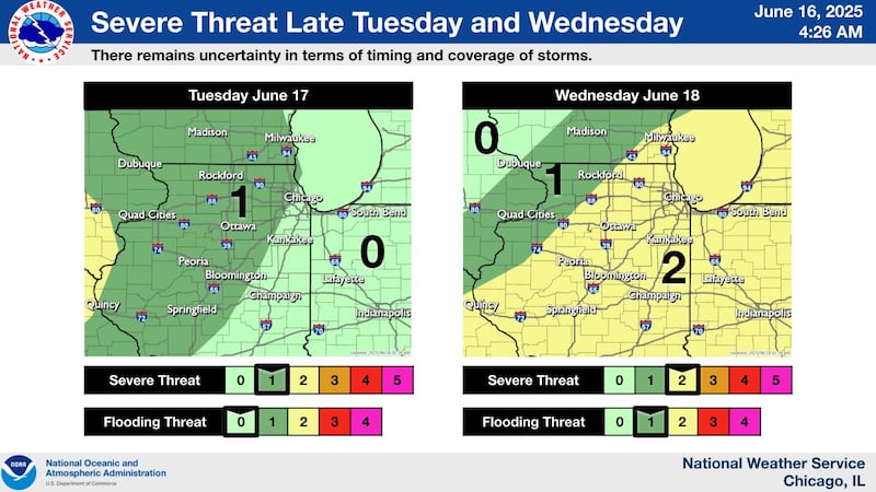
Northern Illinois could see strong to severe thunderstorms late Tuesday and Wednesday, according to the National Weather Service, with the greatest threat expected on Wednesday across the eastern and southern portions of the region.
A Level 1 (marginal) severe weather risk is forecast for much of north-central Illinois on Tuesday, June 17, including McHenry, Lee, Ogle, Whiteside, La Salle, Bureau, DeKalb, Kane and Will counties. The primary threats Tuesday are isolated strong storms and localized heavy rainfall, but widespread severe weather is not expected.
The threat increases on Wednesday, June 18, when a Level 2 (slight) risk for severe storms is forecast for much of northeastern and central Illinois. In these areas, thunderstorms could bring damaging wind gusts, large hail, and heavy rain. Areas farther northwest remain under a Level 1 risk.
:quality(70)/cloudfront-us-east-1.images.arcpublishing.com/shawmedia/VN7APJULHFF5VK3I54OF2MNCE4.png)
The National Weather Service notes that there is still uncertainty about the timing and coverage of the storms on both days. Forecast confidence may improve as the system approaches, and residents are urged to stay updated.
Localized flooding also may occur where storms repeatedly move over the same areas.
Anyone with outdoor plans midweek should monitor the latest forecasts and have a way to receive weather alerts.
For updated information, visit weather.gov.
:quality(70)/author-service-images-prod-us-east-1.publishing.aws.arc.pub/shawmedia/59fc2deb-4690-4608-b846-d6af698839c4.png)