Severe thunderstorms could develop across northern Illinois later today and tonight, with forecasters warning that any storms that form may quickly become dangerous.
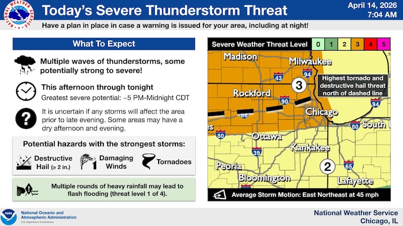
According to the National Weather Service and the Storm Prediction Center, much of the region is under a Level 2 (slight) to Level 3 (enhanced) risk for severe weather on Tuesday, April 14. The greatest threat area includes far northern Illinois, roughly along and north of the Interstate 88 corridor, including communities such as McHenry County, Rockford, Dixon, and DeKalb.
The main window for severe weather is expected from late afternoon through midnight, though confidence remains lower on exactly when, or even if, storms will develop locally before evening. Forecasters say it’s possible that much of the afternoon could remain dry before storms rapidly intensify if they do form.
That includes the potential for large, destructive hail greater than 2 inches in diameter, damaging wind gusts, and tornadoes. The highest tornado and significant hail threat is expected across far northern Illinois, especially near the Wisconsin border.
Additional rounds of storms are expected overnight, increasing the risk for heavy rainfall and possible flash flooding, especially if storms track over the same areas.
Warm, summer-like temperatures in the 70s and 80s will continue through midweek before a more unsettled pattern brings additional storm chances into Wednesday and beyond.
:quality(70)/author-service-images-prod-us-east-1.publishing.aws.arc.pub/shawmedia/59fc2deb-4690-4608-b846-d6af698839c4.png)