Unseasonably warm temperatures on Monday will set the stage for potentially severe thunderstorms across northern Illinois on Tuesday afternoon and evening, according to the National Weather Service.
Forecasters say temperatures on Monday could climb into the lower 70s, possibly setting record highs for March 9 in parts of the region, as breezy southwest winds gust between 25 and 30 mph.
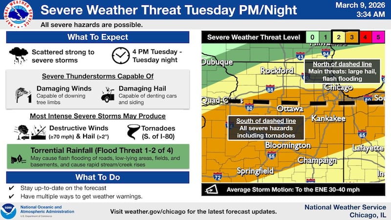
The bigger concern arrives Tuesday as a cold front moves south across the area and interacts with a developing storm system moving out of the Plains. That setup is expected to trigger scattered thunderstorms beginning during the mid- to late afternoon on Tuesday and continuing through Tuesday evening.
The Storm Prediction Center has placed much of northern Illinois in an enhanced risk (level 3 of 5) for severe weather.
Storms developing along and south of Interstate 80 could produce the most intense weather, including damaging winds, very large hail, and tornadoes, forecasters said. The strongest storms may produce wind gusts of at least 70 mph and hail larger than 2 inches in diameter.
Farther north, including areas near the Interstate 88 corridor, storms may still produce large hail and strong winds, even if the tornado risk is lower.
Thunderstorms are expected to move east-northeast at 30 to 40 mph and may persist into late evening, with some activity continuing overnight Tuesday into early Wednesday across southeastern parts of the region.
Heavy rainfall is another concern, with the potential for flash flooding on Tuesday.
Rain is expected to continue into Wednesday morning before tapering off from northwest to southeast.
Another round of strong winds may arrive late Thursday into Friday, when gusts could exceed 40 mph.
Residents are encouraged to stay updated on forecasts and ensure they have multiple ways to receive weather warnings on Tuesday afternoon and evening.
:quality(70)/author-service-images-prod-us-east-1.publishing.aws.arc.pub/shawmedia/59fc2deb-4690-4608-b846-d6af698839c4.png)