Storms are possible in northern Illinois on Sunday as a system passes through the region, and the area could see high wind gusts and falling temperatures Sunday night into Monday.
Widespread showers with embedded storms can be expected Sunday morning through early evening, the National Weather Service said Saturday afternoon.
Some storms could be strong to severe, mainly in the afternoon hours and in areas south of Interstate 80, according to the NWS.
Potential hazards for the region include lightning strikes and gusty winds. Soaking downpours, which can lead to localized flooding, are another risk.
In areas farther south, damaging winds that can bring down tree limbs are a potential hazard, and there is a small chance of a brief tornado, the weather service said.
:quality(70)/cloudfront-us-east-1.images.arcpublishing.com/shawmedia/DMEENBBGGZCEFAYPBKDZBHTB5Q.png)
People are encouraged to be cautious when driving in heavy rain and have multiple ways to get weather alerts.
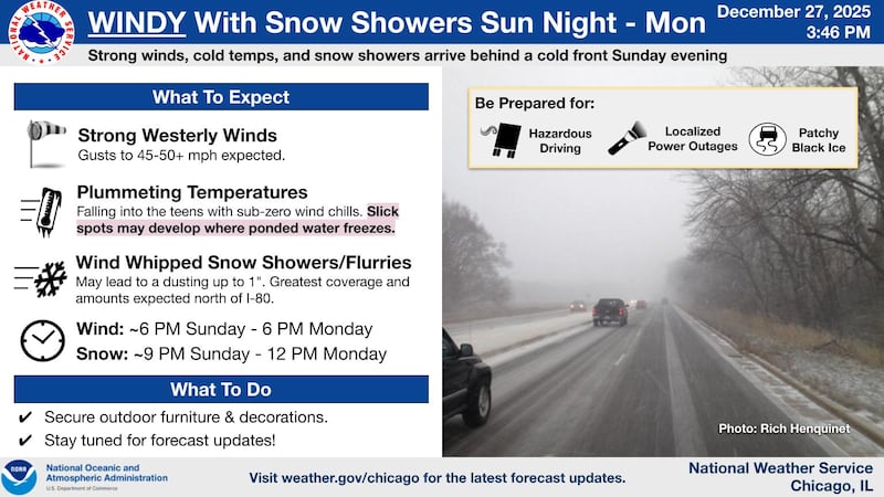
After the storms clear out, strong winds and plummeting temperatures follow.
Wind gusts of 45 to over 50 mph are expected, the weather service said. High winds are anticipated from about 6 p.m. Sunday to 6 p.m. Monday.
High temperatures Sunday could be in the mid 50s to near 60, National Weather Service meteorologist Jake Petr said Saturday. Petr added that it will be cooler in the north and warmer in the south, but the warmth “may not last super long.”
Sunday into Monday, temperatures are expected to fall into the teens with sub-zero wind chills. Petr said Saturday that the plunging temperatures could cause surfaces that are still wet from the rain to freeze very quickly.
Snow showers and flurries are possible through Monday morning. Snow could fall from 9 p.m. Sunday to noon Monday, the weather service said Saturday afternoon. Snow totals could range from a dusting to up to an inch. The greatest amount and coverage of snow is expected north of Interstate 80, according to the NWS.
People should secure their outdoor furniture and decorations and monitor forecast updates, the National Weather Service said, adding people should prepare for hazardous driving, localized power outages and patchy black ice.
The National Weather Service said Saturday morning that locally heavy rainfall is possible Sunday. “Widespread” rain amounts could be 0.25 to 0.75 inches, with some areas receiving 1 to 1.5 inches of rain, according to the NWS.