Most of the tornado warnings issued Friday in the Illinois Valley were for rotating clouds and not for funnel clouds that touched down. One exception was rural Mendota.
The National Weather Service in Romeoville confirmed at 12:35 p.m. Sunday that an EF1 tornado was confirmed by a weather service survey conducted Sunday morning in La Salle County.
“We’re still refining the exact wind speed,” meteorologist Todd Kluber said, “but the range for that is 86 to 110 mph.”
Earlier, the service had indicated that all other tornado warnings issued for the Illinois Valley were the result of rotating clouds picked up by radar. Forecasters had reserved judgment until Sunday afternoon on whether a short-lived twister touched down in the Mendota area near the La Salle-Bureau county line.
:quality(70)/cloudfront-us-east-1.images.arcpublishing.com/shawmedia/YHCXL7K6LFFIRBESWNHNME2N5M.jpg)
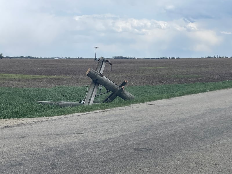
Authorities had, however, reported activity consistent with a twister. Mendota Police Chief Jason Martin said he was aware of were multiple trees and utility poles damaged outside city limits, as well as semis blown over on Interstate 39.
No deaths were reported in Illinois, according to The Associated Press, but the service reported a list of EF-1 tornadoes across north and central Illinois.
The list included Pecatonica, Harrison, and Roscoe – all in Winnebago County – Gibson City in Ford County and Buckley in Iroquois County. Another was reported in rural Livingston County, though the service indicated the storm began in McLean County.
Locally, warnings were sounded after radar picked up rotating clouds in Bureau County south of Princeton and near Toulon in Stark County, which set off alerts in nearby Putnam and Marshall counties. In each case, however, the NWS offices in the Quad Cities and in Lincoln said the alerts were issued when radar picked up cloud rotations.
“There are no reported tornadoes in Bureau or Putnam counties on Friday,” David Cousins, a meteorologist for the NWS office in Davenport, said.
The NWS office in Lincoln, which includes Marshall County, also had no reported tornadoes but emphasized that survey teams had been dispatched to multiple locations.
The warnings were issued as the Midwest was again battered by a line of thunderstorms that hammered Iowa and then moved across northern Illinois.
Fred Moore, director of the La Salle County Emergency Management Agency, issued a statement Saturday urging residents to be cautious during the extensive cleanup.
He warned residents to stay alert for downed power lines, to use generators safely, and to check on their at-risk neighbors. Perishable foods should be discarded if they were thawed by a loss of power for longer than four hours. Additionally, Moore urged residents to be aware of home-repair scams.
Minor flooding is likewise forecast along the Illinois River, with the lower parking lot at Starved Rock State Park likely to be engulfed before the river crests Monday morning.
Major flooding is not expected and Friday’s rain is welcome insofar as the Illinois Valley is shaking off the vestiges of an extended drought.
:quality(70)/s3.amazonaws.com/arc-authors/shawmedia/638ad18c-1176-4018-bcef-b5560cf36d58.png)