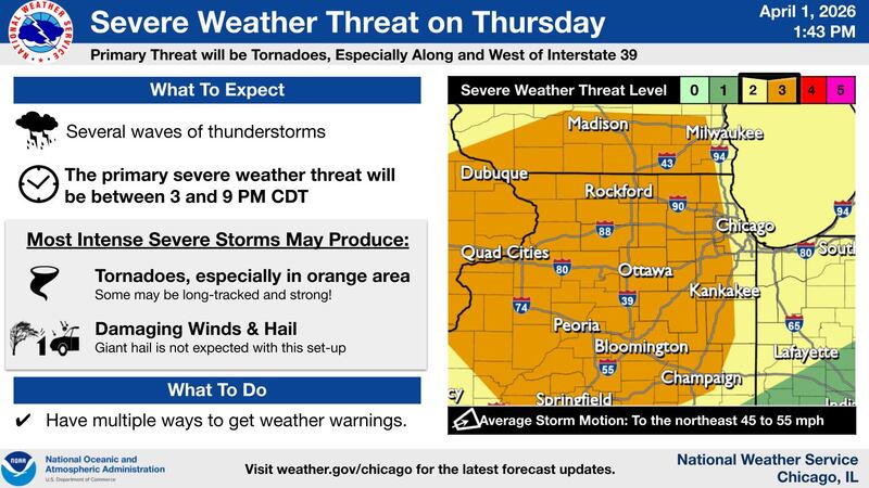
A heightened threat for severe weather, including the potential for strong, long-track tornadoes, is taking shape across northern Illinois Thursday afternoon and evening, according to the National Weather Service.
The Storm Prediction Center has upgraded the region to a Level 3 out of 5 severe weather risk, signaling an increased likelihood of dangerous storms. The greatest concern is for areas along and west of Interstate 39, though severe weather could extend as far east as the Interstate 55 corridor, depending on how conditions evolve.
Thursday’s setup is being driven by a powerful spring storm system moving out of the Plains into the Upper Midwest. Ahead of it, a warm front will lift north through the area Thursday morning, bringing warmer, more humid air and setting the stage for storm development. Temperatures are expected to climb into the upper 60s and 70s, with gusty south winds potentially reaching 40 to 50 mph.
Showers and a few non-severe thunderstorms are expected overnight into Thursday morning, with locally heavy rainfall possible, especially south of Interstate 80, where minor flooding in low-lying areas such as fields and ditches could occur.
The main window for severe weather is expected between 4 and 9 p.m. Thursday.
During that time, conditions may favor the development of supercell thunderstorms capable of producing tornadoes, some of which could be strong or long-tracked. Damaging wind gusts and hail are also possible, though forecasters say tornadoes are the primary concern with this system.
Storms are expected to move quickly to the northeast at 45 to 55 mph, which could limit warning lead time and increase the danger for those in their path.
While the setup is concerning, forecasters note that severe weather is not guaranteed. Widespread cloud cover or early-day storms could limit instability and reduce the overall threat. Still, residents are urged to closely monitor forecasts and be prepared to act quickly if warnings are issued.
Additional rounds of showers and thunderstorms are possible Friday into Saturday, with a lower-end severe risk.
:quality(70)/author-service-images-prod-us-east-1.publishing.aws.arc.pub/shawmedia/59fc2deb-4690-4608-b846-d6af698839c4.png)